
Greetings
Welcome to Ogawayama in English.
This is a rock-climber's guide to a place called Ogawayama, which, despite increasing competition and at times unbearable overcrowding, remains the best all-round rock-climbing area in Japan.
The guide is permanently a work in progress, so bear with me if you come across a bit that isn't finished yet.
If you have any suggestions for the guide, particularly on grades and routename translations, please let me know at neil_AT_ogawayama_DOT_online.
Here's a little message for Japanese climbers: 
And so, to business:
2024 Lodge/Campsite Opening
The lodge and campsite will be open again from April 26th.
- No apologies for the colour scheme, but I do recommend that you expand your browser to full size.
- If a route name is a link, click it to see a photo of the route.
- I'd like to get hold of some decent photos of routes. If you've got any you'd like to see up, send them along.
- I used a 5-star system for the grading the quality of routes. Something like this:
- No stars: Really dire
- *: Pretty average
- **: Good
- ***: Very good
- ****: Excellent
- *****: Special
Keep in mind that you might not like the same stuff I do.
- I keep changing things. See Updates for details.
- Mostly clip-ups, tons of slabs, a lot of cracks, a fair amount of face-climbing and a few roofs.
- Mostly one-pitch routes, but no shortage of the other sort.
- The bouldering around the campsite is also superb.
- It's granite, it's good and there's a lot of it.
- There's plenty of unclimbed stuff around, but keep in mind that it's unclimbed for a reason (i.e. dead hard, crap rock, or too far from the campsite). Most routes climbed since, say, 1998 near the campsite are a bit grotty.
- The American grading system is used in Japan.
- I've used a mixture of personal experience (of my own and of friends) and existing guides when grading routes. And in a couple of cases I just made it up.
- I've climbed something like 90% of routes up to and including 5.11d at least once. I've done a handful of 12s, but really, 12a and up, you're on your own. Comments on grades are welcome.
- Unless otherwise stated, routes are entirely protected by fixed gear.
- Just because a guide, even a good one like this, says there's gear in place, doesn't mean it's still there.
- On closer acquaintance, it will become apparent that 'bolt' has several meanings in Japan, ranging the full gamut from a bolt so sexy you could hang an orgy off it to what can only be described as a rusty stain with a hole - it is up to you whether or not to trust the things you clip.
- Having said that, the Japan Free-Climbing Association, bless their five-toed socks, occasionally replace some of the more antique bolts, so you could receive a pleasant surprise on some routes.
- Don't trust fixed ropes.
- Carry some spare tat and that grotty karabiner that you'd have thrown away by now if it didn't seem such a waste - especially on the more obscure routes, you might not be happy with what passes for an anchor.
- In which case, a penknife might come in handy.
- Drawn freehand, badly and not to scale.
- 'x' represents a bolt, a blue line represents fixed rope.
- A line of little squares represents a dike.
- Kimpu-san Highway - This is the drivable track that runs parallel to Nishi Matasawa. After 5km, it narrows and climbs left (east) up to the summit of Kimpu-san. Continuing straight will take you to Mizugakiyama, while another path heads right (west) to Mount Ogawayama.
- Panorama Hiking Course - This is a short course that runs in a loop from the main carpark to Yane Ippou. Clockwise: Follow the track that snakes up from the main carpark. Where the bends end, the track narrows and forks at a prominent boulder called Bunki Iwa. Take the right fork. This climbs steadily past paths leading to various Roof Rocks till just below Omusubiyama Slab. It then drops down more steeply before returning to the carpark. The anti-clockwise route gives you a steep climb followed by a gentle descent. It should take about 30 minutes.
- Kamoshika Hiking Course - This is a longer loop that runs from the lodge to Karasawa Waterfall. Clockwise: Follow the Kimpu-san Highway for 300m to signs on the right (just after the toilet block on the left). Break off right and climb alongside Hachiman Zawa past various rocks, with a tiny bit of scrambling and a couple of ladders for good measure. Where the path disappears into a more wooded ridge, a second path is signposted dropping steeply to the right. Follow this to Karasawa Waterfall. (Continuing on the ridge will take you to Ogawayama peak.) Anti-clockwise: Follow the clockwise version of the Panaorama Hiking Course to Bunki Iwa, but take the left fork to Karasawa Waterfall. From here, cross the stream and climb steeply to the start of the Shin-Ogawayama Hiking Course on the ridge. Turn left to scramble up down and around rocks before zig-zagging back down to the campsite. It should take about 60~90 minutes, depending on how often you stop to take in the views.
- Shin-Ogawayama Hiking Course - This breaks off from the highest point of the Kamoshika Hiking Course and goes to the summit of Mount Ogawayama.
- Shakunage Trail - This is a short trail (1.5km) that runs parallel to Nishi Matasawa away from the campsite. You can drop down to it from various points below the lodge. It's useful for accessing Riverbank/Streamside Areas and some new bouldering areas. It eventually returns you to the road just above the carpark with the annoying deer-bothering buzzer.
- The biggest stream that you will encounter is called Nishi Matasawa. This is the one you have to cross to get to the Family Rocks. The places where you can cross this without getting your feet wet vary from year to year. Sometimes it's just best to take your shoes and socks off and take the plunge.
- Be prepared to use some initiative when other streams are mentioned in approaches or drawn on maps - they may well be dry, especially early and late in the season.
- It doesn't rain in Japan - it pisses down - and dry stream beds can turn into unfordable torrents in a very short time.
Glorious. A cloudless, moonless night is just spectacular.
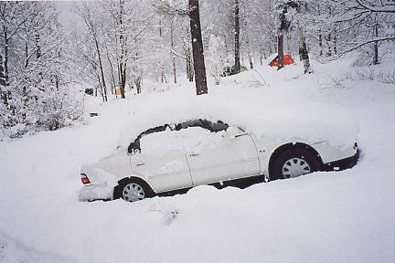
The campsite is located at 1,600m altitude. It's bloody cold (at night) from November to May, though if you get lucky you can find yourself climbing in T-shirt and shorts in the daytime. (Incidentally, 25cm of snow fell on the night of May 2nd, 2001 - a rarity, but it can happen. Take a look.) June is well warm enough, but late June/early July is often rained out. For most people, the season is from late July to September.
Be warned: The place heaves during the bulk of Golden Week, the August national holiday (usually 13th-15th) and any three-day weekend (these have become quite common since Happy Monday Syndrome hit Japan).
You might want to check the weather before you go. Try these:
There are lots of ways to get there. This is the one I know:
- You are heading north on Route 141; you go up and up through Kiyosato and hit Nobeyama; turn right at the first junction after a fork at a traffic signal - Kawakamimura is prominently signposted.
- Follow this road for 4km till you start going downhill and hit another prominent sign for Kawakamimura; turn right and follow this road up and down till it ends at a T-junction (at a big supermarket called Nana's - last chance for a decent stock-up - opens at 9am). (Note: A new road will open late in 2024 that bypasses Nana's.)
- Turn right and follow this road through a couple of villages towards Akiyama; just before the village, as you climb out of an S-bend with a tractor shop on the right, turn right up the Akiyama bypass - this is the second of two right-turns very close together. The sign is not clear, but don't worry if you miss it - you can take the old road: follow the road through Akiyama and turn right just after the village at a sign for Kawahage (there is also a convenience store - with veg and booze - on the right 100m before this turning).
- Turn right at the top of the bypass to rejoin the old road. Follow this road for about 3km (across a bridge and up a hill through Kawahage village) till you start going downhill and round an S-bend; as you start to come out of the bend, the road forks - take the righthand, uphill fork (i.e. don't go under the ornamental gate).
- Stay on this road till it disappears into woods and forks again - take the righthand, uphill fork again; follow this to the barrier that marks the beginning of the campsite.
- If you want to punch a phone number into your funky navigation system, the number of the phone in the lodge is 0267-99-2428.
- Google map says it's here.
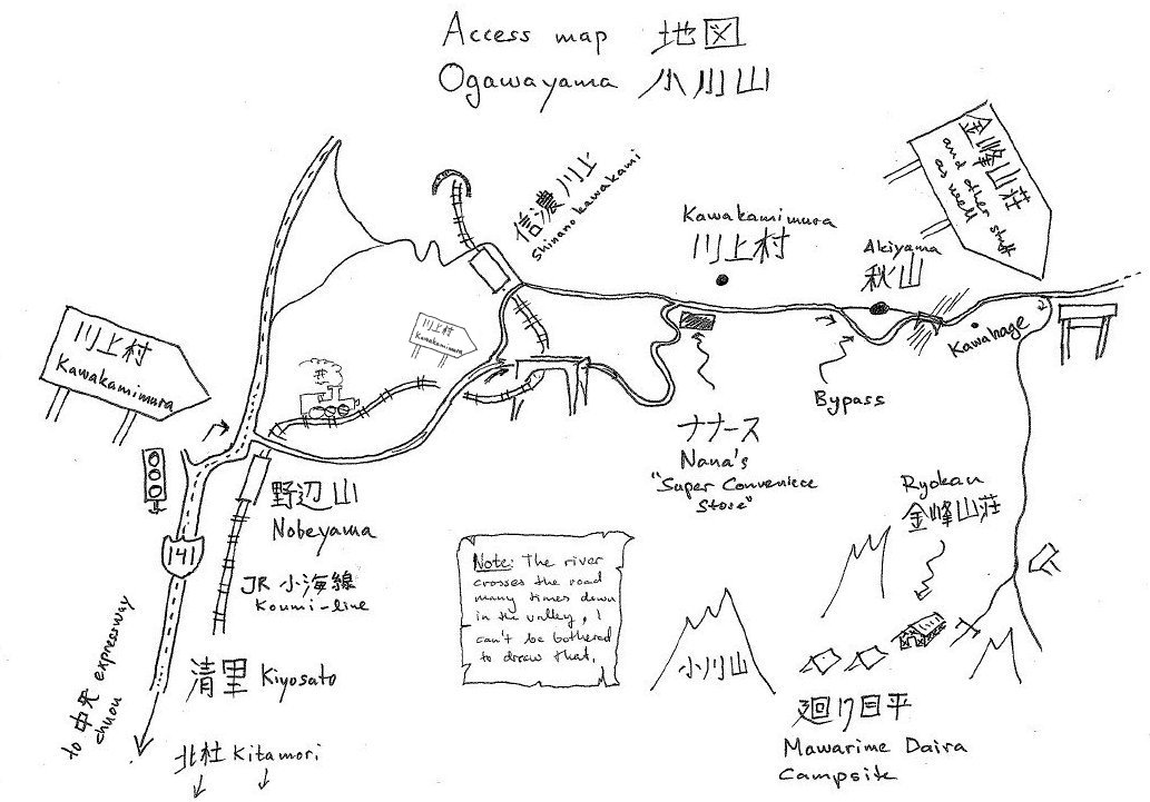
Jonas Wiklund kindly let me have a copy of the sketch map he did for his excellent article introducing bouldering at Ogawayama. Click here for the map.
Amazingly, some people don't have their own wheels. This is for you.
Hitching is extremely rare in Japan, so while there's a bit of novelty attached and it can be done, it is a very unreliable way of getting from A to B.
Public transport will take you as far as Kawahage. To get there, wherever you're coming from, you first need to get to Shinano-Kawakami station on the JR Koumi line. From there take a 30-minute bus ride to Kawahage terminus (about one every two hours between 7am and 7pm, and usually timed to leave just before the train arrives - timetable here). From Kawahage, you can look forward to a gently rising 40-minute walk to the campsite (possible to hitch once you get up onto the "main" road).
There is a taxi service from Shinano-Kawakami station, but it is expensive and inconvenient.
The campsite is known as Mawarime Daira, which means something like Panorama Plain. It's just about as big as you want it to be - but most people seem abnormally attracted to the toilets, so they don't spread out much. The main part of the campsite centres on Kimpu Sansou - the relatively huge and luxurious mountain lodge. Unfortunately, the campsite is also popular with boulderers, hikers, families and other non-climbers, so expect a crowd - Japanese style - most summer weekends.
There is a climber-centric Japanese homepage for the campsite here.
This includes an excellent English language map of the crags around the campsite.
Some things you should know:
- It costs 500 yen for a day trip if you manage to get in and out between 4am and 7pm. Any earlier/later and you're charged for the night.
- Camping is 900 yen per person per night. You can also rent a tent, rent a shed, or stay in the lodge itself. The rentatents and the wooden platforms on which they are pitched cost 2,000 yen a night and are intended to sleep 4 in comfort. (You will be asked to pay the 2,000 yen even if you pitch your own tent on the platforms.) The sheds also sleep 4 and cost 6,000 yen.
- The lodge does not accept credit cards.
- When you pay to leave, it is assumed that you will be out of the gate within 30 minutes. If you need longer (for example, if you intend to leave late at night), say so when paying (otherwise, your ticket for raising the gate will time out).
- Facilities include toilets, washing areas, a shower block and all the firewood you can eat.
- It is illegal to take a tool of any sort to a standing tree (dead or alive). Please respect this as, in the worst-case scenario, it could lead to a campfire ban. There is plenty of firewood in the woods.
- The lodge sells things such as climbing guides, gas canisters, wine and souvenir tat. Expect a 20% markup.
- There is a bathhouse in the lodge - 500 yen a dip (bring your own towel, soap, etc).
- There is a shower shack in front of the lodge - 100 yen a pop, and not bad according to the last person I know who used it.
- There is a shelter across the road from the lodge with various drink (including beer) and snack machines.
- Take your rubbish home with you. The lodge will only accept rubbish if it is sorted and bagged in designated bags (which you must buy at the lodge).
- Generally, the rules of the campsite fall within the bounds of common sense and the staff at the lodge are friendly and helpful. The most banged on about rule is: Keep the noise down after 9pm.
Note:
The lodge is closed from mid-November to mid-April. During this period, the barrier across the entrance is left open and you can camp for free, but note that all of the electricity and water outlets are turned off and the toilets are locked.
- The long wait for a decent guide to the area (apart from this one, of course) is over. Naoya Naitou, who did the superb Mizugaki guides, has completed work on a new guide. It's published by Frontier Spirits and has no ISBN. Unfortunately for your pocket, it's in 3 volumes, as follows:
- Ogawayama Climbing Guide Joukan (Volume 1, everything on the right (east) bank of Nishimatazawa)
- Ogawayama Climbing Guide Chuukan (Volume 2, everything not in Volumes 1 and 3)
- Ogawayama Climbing Guide Gekan (Volume 3, Roof Rocks and To the Waterfall)
- Previously, the best available guide was volume 3 of Makoto Kitayama's series of guides to climbing areas in Japan - Nihon Hyaku Iwaba 3: Izu/Koushin (ISBN 4635180832). This also includes the nearby Kasamerisawa, Fudousawa and Mizugakiyama areas, as well as Jouyama and the Jougasaki sea-cliffs in Shizuoka prefecture. Current edition 2012 (with the blue dust jacket - green is the old (2001) version).
- Kitayama also produced a "Selected Climbing Areas in Japan" (ISBN 4635180026) which contains Ogawayama, as well as Hourai and Futagoyama, which are the two biggest and best pure sport climbing venues in Japan. This is more of a keep-at-home guide, being B5-size and full of glossy pics. "Current" edition 1995.
- Kantou Shuuhen no Iwaba by Toshiyuki Kikuchi (ISBN 9784894752047) covers the whole Kantou area, but the detail suffers a little as a result. Re-issued in 2017 with a more selective approach and some imaginative route grades.
- Specifically for the boulderers, Kitayama also made Nihon Bouldering Area (Kami). (This has "Bouldering Area in Japan" on the front.) Be sure to get ISBN: 9784635160162 for Ogawayama. Or, better still, buy a rope instead.
- There is a new bouldering guide for August 2020 that is allegedly bilingual: Ogawayama Bouldering Area Guide, compiled by Tokio Muroi.
Standard Disclaimer:
Climbing's a dangerous game. Be careful. If you get killed, it's not my fault.
Non-standard Disclaimer:
There's bears in them hills. Be careful. If you get eaten, it's not my fault.
Substandard Disclaimer:
Climbing dangerous careful killed fault.